SNODLAND: Holborough Hill (a.k.a. the nob)
Denis
Anstey
The links to the right will take you to the website of the Kent Archaeological Society and to the report published in Archaeologia Cantiana
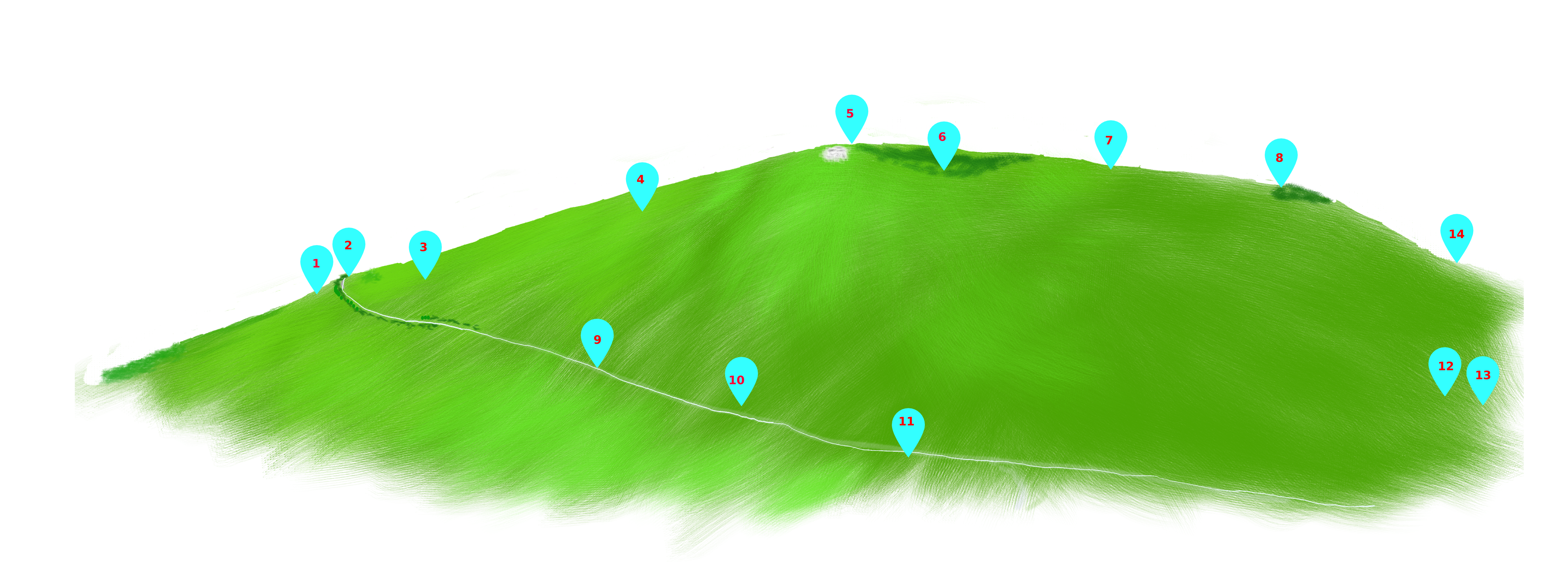
| 1 |
Old
chalk pit - victorian rubbish dump |
|
| 2 |
Five
Wents (ways or paths) |
|
| 3 |
Cobblers
Hole |
|
| 4 |
Ladykey |
|
| 5 |
Bronze
age ring ditch - mound lost to erosion |
http://www.kentarchaeology.org.uk/Research/Pub/ArchCant/Vol.070%20-%201956/070-04.pdf |
| 6 |
Site
of windmill |
|
| 7 |
Anglo
saxon cemetery |
included
in Bronze age ring ditch (above) |
| 8 |
Roman
Tumulus with insertion burial |
Update
- Please read before downloading original article below http://www.kentarchaeology.org.uk/Research/Pub/ArchCant/Vol.068%20-%201954/068-01.pdf |
| 9 |
White
Dyke Road (Way) |
|
| 10 |
Coney
Hall Farm |
|
| 11 |
Diversion
to join lower road (First documented in 1740) |
|
| 12 |
Anglo
Saxon hut group with sword moulds. First indication of high quality iron working in the area. |
|
| 13 |
Windmill
(c1824) |
|
| 14 |
Hoard of swords, spear heads and knives. |
1 Old chalk pit (date unknown)
later used as a dump from which a large number of old bottles
were recovered. Now ploughed out.
2 Five Wents - the meeting of 5
ways or paths. Paths were usually direct and favoured over
roads. Although a significant destination is given the
ways would have extended far beyond. Destinations were
Paddlesworth, Meopham, West Malling, Holborough/Halling and
Snodland Ford.
3 Cobblers Hole. Probably a
pit dug by Chalk Cobblers. Many of the paths in the area
are cobbled.
4 Ladykey - one of a number of
dialect names for a Cowslip.
Eye witnesses tell of a profusion of cowslips growing on this
part of the hill which offered a well-drained habitat with a
south west aspect.
5 Bronze age ring ditch. The mound
was absent due to erosion. This is the highest part of the
hill at 210 feet (64 m).
6 Site of windmill. First mentioned
in the Wotton Survey 1557-60 as 'Monks' Tippit', and later in an
estate map of 1740 as a 'smock hole'. The two are very
similar garments and typical of the naming of landscape
features.
7 Anglo Saxon Cemetery. We do not
know the size or extent of the cemetery. Archaeology and
preservation were not high on our list of priorities during war
time.
8 Roman Tumulus with insertion
burial.
9 White Dyke Road/Way.
10 Coney Hall Farm. A coney is a
rabbit.
11 White Dyke way diverted to a lower road.
12 Anglo saxon hut group with sword
moulds.
13 Windmill near clock tower (1824
Malling to Strood Toll Road map) Owner Mr. Stone Occupier Mr.
Boorman. William Coles Finch records that the windmill was
purchased about 1839 by one of the Stedman family, transferred
to Gillingham and re-erected there. It was struck by
lightning and burnt down in a violent storm which raged on the
night of June 28th, 1892.
14 Collectanea Cantiana (1893) George
Payne p.137
'Mr. Raven (of the Cedars) informs me that when the new road was
made, which leads from Holborough towards the mound, Anglo-Saxon
swords, spear heads and knives were found; they are now in
his possession'. These items have been traced to Guildhall
Museum, Rochester. The artefacts could have come from
graves but the tithe map indicates the existence of a
burh. A burh was a defensive position created to defend
against Viking invasions c900 AD and to provide shelter for the
local population. Note the raids up the Medway and the
sacking of Malling Abbey.